


LOCHEUR 2015bis

UDGI54
User
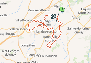

Length
35 km

Max alt
216 m

Uphill gradient
654 m
Km-Effort
43 km

Min alt
55 m

Downhill gradient
628 m
Boucle
No
Creation date :
2015-04-14 00:00:00.0
Updated on :
2015-04-14 00:00:00.0
8h00
Difficulty : Unknown

FREE GPS app for hiking
 SityTrail
IGN / Geographical institutes
SityTrail Plus
The world is yours!
About
Trail Other activity of 35 km to be discovered at Normandy, Calvados, Val d'Arry. This trail is proposed by UDGI54.
Positioning
Country:
France
Region :
Normandy
Department/Province :
Calvados
Municipality :
Val d'Arry
Location:
Le Locheur
Start:(Dec)
Start:(UTM)
678923 ; 5442100 (30U) N.
Comments